
Summaries of the Arctic Expedition Report Aboard the CCGS Amundsen (2022) - Translated in 3 Languages
 10.26071/ogsl-c73c4b31-6480
Access and Use
|
Licence: Creative Commons Attribution 4.0
Limitations: Do not use for navigational purposes. |
Data and Resources
Citation
Dataset extent
Dates
| Metadata Reference Date(s) | April 11, 2023 (Publication) June 16, 2023 (Revision) |
|---|---|
| Data Reference Date(s) | September 09, 2022 (Creation) |
| Frequency of Update | As Needed |
Contacts
- Affiliation
-
Amundsen Science

- Role
- Custodian
- Distributor
- Owner
- Name
- Ratsimbazafy, Tahiana
- Affiliation
-
Amundsen Science
- Role
- Custodian
- Point of Contact
Additional Info
| Field | Value |
|---|---|
| Ocean Variables | Other |
| Scope | Dataset |
| Status | Completed |
| Maintenance Note | Generated from https://cioos-siooc.github.io/metadata-entry-form |
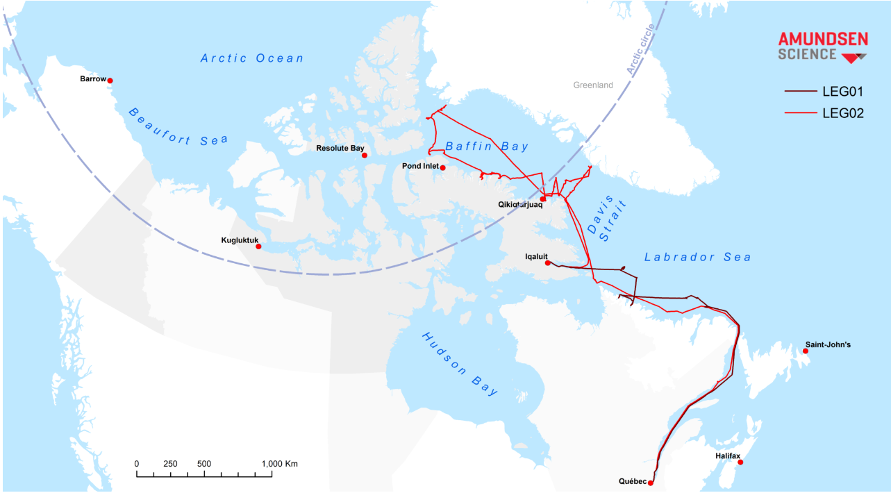
| Spatial Extent | { "coordinates": [ [ [ -72.63, 77.85 ], [ -77.91, 76.82 ], [ -80.02, 75.76 ], [ -79.55, 75.36 ], [ -80.37, 74.47 ], [ -78.84, 73.76 ], [ -75.09, 72.22 ], [ -72.17, 71.46 ], [ -70.17, 70.81 ], [ -66.89, 69.74 ], [ -60.92, 66.19 ], [ -63.85, 64.93 ], [ -66.78, 66.19 ], [ -68.06, 65.76 ], [ -65.02, 64.37 ], [ -63.96, 63.86 ], [ -64.43, 61.1 ], [ -63.73, 59.35 ], [ -60.45, 55.51 ], [ -57.24, 54.51 ], [ -56.71, 53.77 ], [ -55.69, 53.29 ], [ -55.69, 52.38 ], [ -55.81, 51.99 ], [ -57.15, 51.42 ], [ -58.91, 50.98 ], [ -60.2, 50.16 ], [ -62.54, 50.28 ], [ -65.09, 50.28 ], [ -66.62, 50.18 ], [ -67.38, 49.54 ], [ -68.37, 49.12 ], [ -69.08, 48.56 ], [ -70.22, 47.74 ], [ -70.98, 47.08 ], [ -71.54, 46.74 ], [ -71.1, 46.76 ], [ -70.31, 47.18 ], [ -69.25, 48.01 ], [ -68.2, 48.68 ], [ -66.85, 49.1 ], [ -64.92, 49.44 ], [ -64.13, 49.98 ], [ -63.6, 49.86 ], [ -62.31, 49.52 ], [ -61.69, 49.43 ], [ -60.76, 49.23 ], [ -59.41, 49.41 ], [ -58.09, 49.88 ], [ -57.5, 50.56 ], [ -57.09, 50.96 ], [ -56.42, 51.44 ], [ -55.83, 51.62 ], [ -55.19, 51.84 ], [ -54.37, 54.08 ], [ -55.22, 55.9 ], [ -57.43, 61.73 ], [ -53.97, 65.89 ], [ -53.79, 68.54 ], [ -54.67, 68.78 ], [ -57.17, 72.53 ], [ -67.6, 76.21 ], [ -72.63, 77.85 ] ] ], "type": "Polygon" } |
| North Bounding Latitude | 46.74 |
| South Bounding Latitude | 77.85 |
| East Bounding Longitude | -53.79 |
| West Bounding Longitude | -80.37 |
| Temporal Extent |
|
| Vertical Extent |
|
| Default Locale | English |
| Citation identifier |
|
| Included in Data Catalogue |
|