
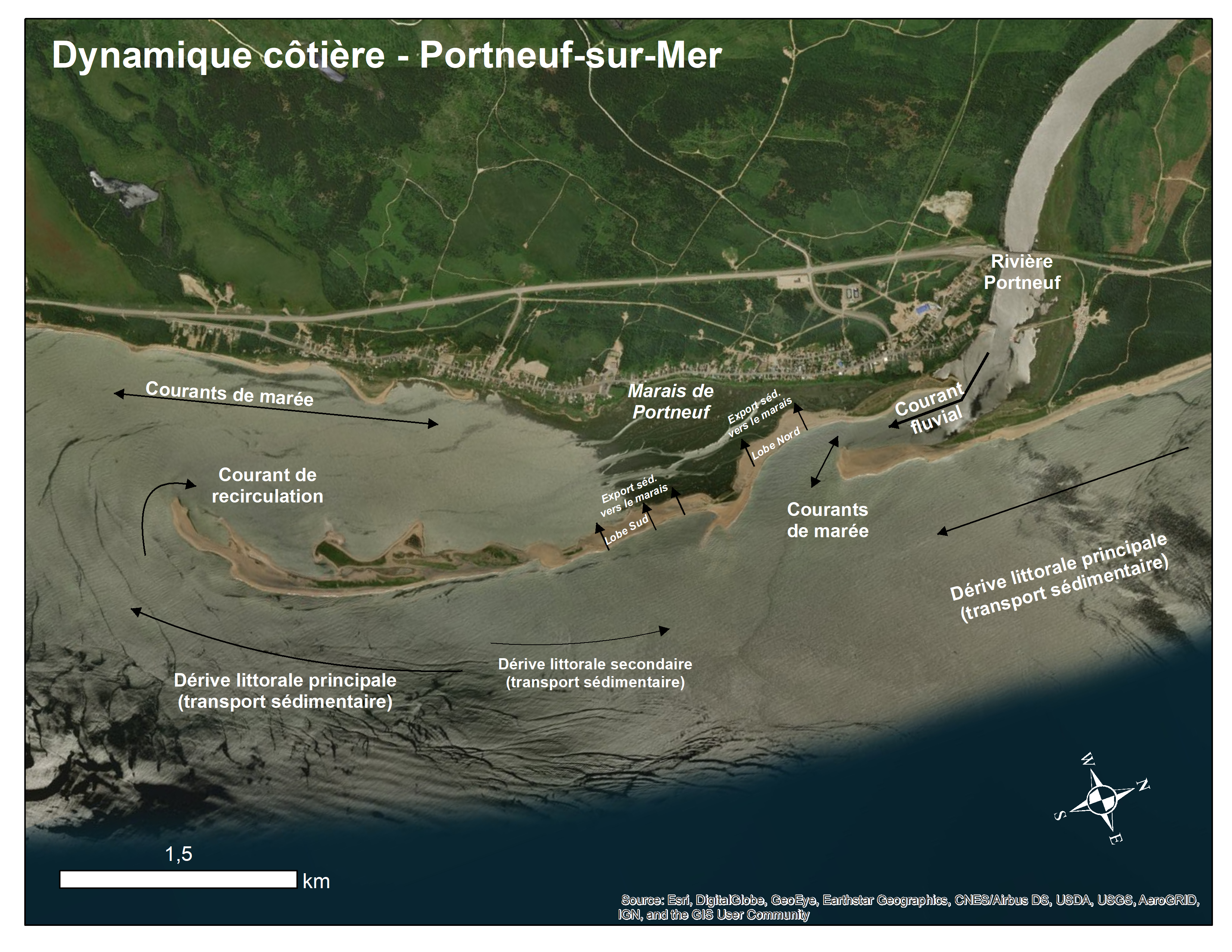
Geomorphological Survey of the Salt Marsh and the Sandspit of Portneuf-sur-Mer (2018)
Access and Use
|
Licence: Creative Commons Attribution 4.0
|
Data and Resources
Citation
|
Comité ZIP de la Rive Nord de l’Estuaire. (2020). Geomorphological Survey of the Salt Marsh and the Sandspit of Portneuf-sur-Mer (2018) [Data set]. https://catalogue.ogsl.ca/dataset/ca-cioos_3d240e81-b6b5-481c-b995-f58370deb7bc?local=en
|
Dataset extent
Dates
| Metadata Reference Date(s) |
April 04, 2023 (Publication) December 22, 2023 (Revision) |
|---|---|
| Data Reference Date(s) |
October 27, 2018 (Creation) March 25, 2020 (Publication) March 25, 2020 (Revision) |
| Frequency of Update | As Needed |
Metadata Source
|
Access full metadata here Source last modified December 22, 2023 at 16:40 Other records harvested from zip-rne_metadata_files_autogenerated |
Contacts
- Affiliation
- Comité ZIP de la Rive Nord de l'Estuaire
- Role
- Distributor
- Originator
- Owner
- Name
- Maltais, Marie Karine
- Affiliation
- Comité ZIP de la Rive Nord de l'Estuaire de l'Estuaire
- marie.karine.maltais@zipnord.qc.ca
- Role
- Custodian
- Point of Contact
- Name
- Morissette, Antoine
- Affiliation
-
Université du Québec à Rimouski

- Role
- Collaborator
- Name
- Boivin, Maxime
- Affiliation
-
Université du Québec à Chicoutimi
- Role
- Collaborator
- Name
- Joyal, Gabriel
- Affiliation
-
Université Laval
- Role
- Collaborator
Additional Info
| Field | Value |
|---|---|
| Ocean Variables |
|
| Climate Variables | Surface Currents |
| Scope | Dataset |
| Status | Completed |
| Maintenance Note | Generated from https://cioos-siooc.github.io/metadata-entry-form |
| Spatial Extent | { "coordinates": [ [ [ -68.935504, 48.697881 ], [ -69.238746, 48.697881 ], [ -69.238746, 48.485836 ], [ -68.935504, 48.485836 ], [ -68.935504, 48.697881 ] ] ], "type": "Polygon" } |
| North Bounding Latitude | 48.485836 |
| South Bounding Latitude | 48.697881 |
| East Bounding Longitude | -68.935504 |
| West Bounding Longitude | -69.238746 |
| Temporal Extent |
|
| Vertical Extent |
|
| Default Locale | French |
| Included in Data Catalogue |
|